
In the realm of developing a wider perception and spatial mapping, groundbreaking technology has emerged. Causing transformation in mankind’s understanding of the world around us. Lidar laser, short for light detection and ranging laser, has become a game-changer across industries. Which enables precise measurements, high-resolution mapping, and advanced spatial analysis. The adoption of the Lidar laser technology has begun to rise because its unique capabilities are revolutionizing various sectors.
In this blog, we will explore the capabilities of the Lidar laser, and its applications, discussing the latest innovations propelling its potential. The applications are far-fledged in autonomous systems, mapping and surveying, space exploration, and environmental monitoring.
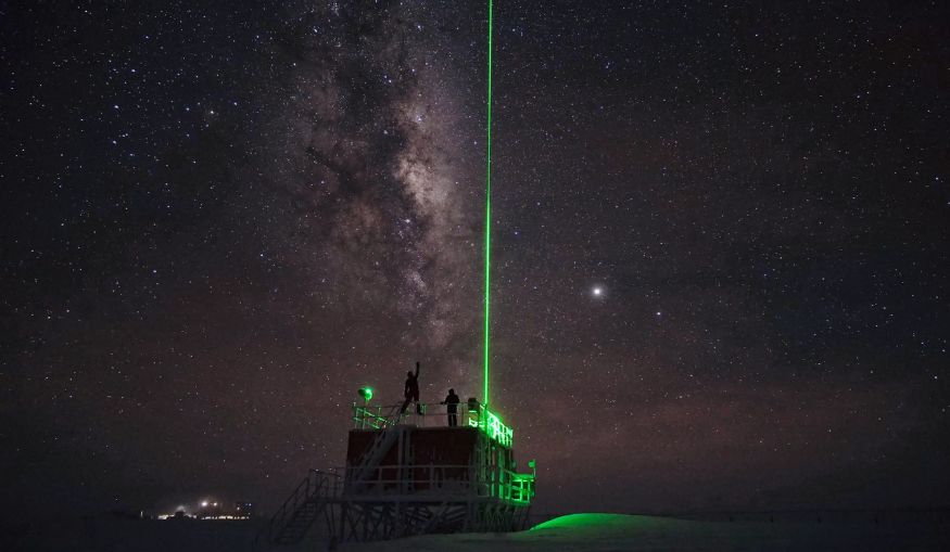
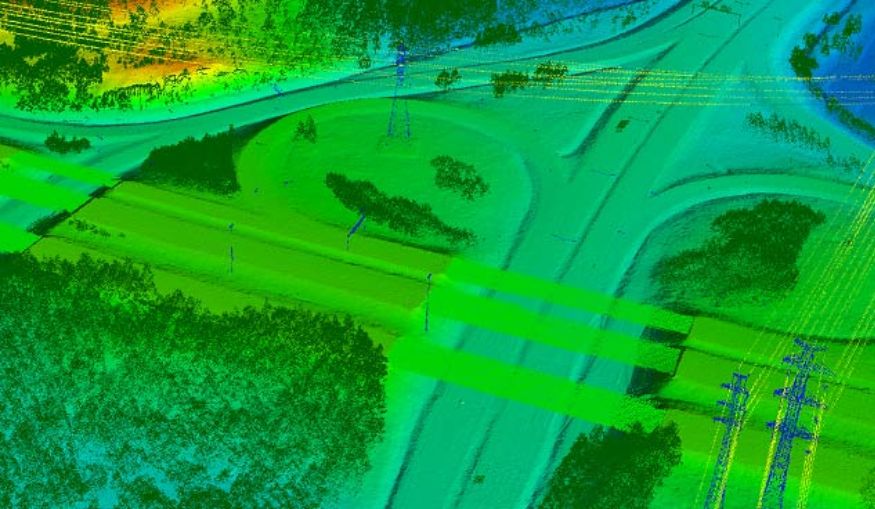
The primary concept lies in the initial use of laser light to determine distances and analyze the working environment. Lidar laser systems emit laser pulses, that bounces off object and return back to the sensor. This technology offers immense advantages in terms of accuracy, resolution, and range. Its ability to generate high-resolution 3D maps with remarkable detail, capturing intricate features of the environment is remarkable.
The system calculates the distance to objects by precisely measuring the time it takes for the light to return to the sensor. The calculated data, combined with the sensor’s ability to capture the intensity of the reflected light, enables the creation of detailed 3D maps and spatial information.
Whether it’s precise measurement of buildings, vegetation, or even small objects, the lidar laser excels in providing accurate spatial data. The laser stays unaffected by ambient lighting conditions and operates effectively both day and night. These features make it a reliable solution for perception and mapping tasks.

The Lidar laser has emerged as a pivotal technology for real-time perception and obstacle detection for autonomous systems. Self-driving vehicles, in particular, heavily rely on Lidar sensors to perceive their surroundings and make informed decisions on movement.
By deploying multiple Lidar laser sensors around the vehicle, a comprehensive 360-degree view of the environment is obtained. These sensors continuously scan the surroundings, detecting and measuring the distance to objects, pedestrians, and other vehicles. Such real-time perception allows autonomous vehicles to navigate safely, anticipate potential hazards, and respond swiftly.
Compared to other sensing technologies, such as cameras or radar, the Lidar laser offers unique advantages. While cameras are susceptible to changes in lighting conditions and radar struggles with accurately identifying object shapes. LiDAR excels in providing precise and reliable distance measurements. Its ability to create high-resolution 3D maps of the environment enhances the perception capabilities of autonomous systems. Quoting them as more robust and capable of operating in complex scenarios.

The impact of Lidar laser technology extends far beyond autonomous systems. In the field of mapping and surveying, it has revolutionized data collection and precise analysis. Traditionally, creating accurate topographic maps and terrain models requires extensive field surveys and manual measurements. With the LiDAR, these processes have been streamlined.
Lidar laser enables the rapid acquisition involving vast amounts of spatial data, which facilitates the creation of accurate topographic maps, digital terrain models, and building information models. Flying the Lidar-equipped aircraft over an area or using ground-based Lidar systems creates highly detailed 3D maps generated with exceptional precision. This technology is particularly useful in challenging terrains or environments where access is difficult.
Space exploration has embraced Lidar laser technology for its unique capabilities. It plays a vital role in remote sensing, atmospheric analysis, and planetary mapping. In remote sensing applications, LiDAR sensors arranged on satellites or orbiters provide valuable data about Earth’s surface, atmosphere, and vegetation.
Scientists analyze various parameters, including elevation, vegetation density, and atmospheric composition, by measuring the reflected laser light. Analyzed information contributes to our understanding of climate change, environmental monitoring, and natural resource management.
In space exploration missions, Lidar laser technology has proven instrumental in mapping and studying celestial bodies. The sensors aboard spacecraft can precisely measure the distances to asteroids, moons, and planets, allowing for accurate mapping of their surfaces. This data helps scientists unravel the mysteries of celestial bodies, understand their geological features, and plan future missions with greater precision.
Environmental monitoring and conservation efforts have also benefited significantly from LiDAR technology. The laser sensors play a crucial role in assessing environmental factors such as forest health, monitoring coastal erosion, and measuring air quality. In forestry applications, the Lidar laser penetrates the deep canopies and provides detailed information about the structure and density of vegetation. The read data aids in forest management, detecting areas affected by diseases or pests, and estimating biomass.
The coastal areas are prone to erosion, and monitoring these changes is crucial for effective conservation. LiDAR sensors accurately measure coastal topography, track changes in shoreline position, and provide valuable insights into erosion rates. These help coastal managers develop strategies to mitigate erosion and protect vulnerable areas.
The Lidar laser technology contributes to effectively accessing air quality monitoring. By the analysis of the backscattered laser light, LiDAR sensors detect and measures particles in the surrounding atmosphere. Such data enables the assessment of air pollution levels, the identification of pollution sources, and the development of strategies for improving air quality.
As Lidar laser technology continues to evolve, ongoing research and development efforts aim to enhance its performance and reduce costs. Innovations in sensor design, signal processing algorithms, and data analysis techniques are expanding the capabilities of these laser systems. The miniaturization of LiDAR sensors allows for integration into smaller devices and applications, further expanding its reach.
One promising direction for Lidar laser technology is the development of solid-state Lidar systems. The technology offers attractive benefits of increased reliability, reduced size and weight, and improved affordability.
The LiDAR technology brings vast and promising applications to the upcoming future. The potential to leverage the capabilities of these lasers for enhanced perception, navigation, and urban planning is vivid.
Lidar laser technology has opened a wild gateway to possibilities toward elevating perception in and around spatial mapping. The laser has transformative capabilities, acquiring the stage for applications in a huge range of industries. LiDAR has proven to be a beneficial tool for acquiring precise spatial data and evolving higher with generating high-resolution 3D maps.
Enabling us to make more informed decisions, protect our environment, and advance our understanding of the world around us. As technology advances, the Lidar laser is set to become an integral part of our everyday lives, contributing to safer transportation, more efficient resource management, and a deeper understanding of our environment.
As LiDAR excels, professionals and enthusiasts need to stay informed about the latest advancements and applications. By embracing this laser and exploring their potential, the industry opens doors to a future where perception and spatial mapping reach new heights.
At InPhenix, we have lived a competitive business life and understand the importance of staying at the forefront of technological advancements. We designed high-quality Light Detection and Ranging (LiDAR) systems.
As Lidar laser technology reaches new advancements and finds useful applications. Businesses must know it is essential to partner with a company that provides the latest and most reliable solutions. We at InPhenix have a team of highly talented individuals, supporting your business in harnessing the power of LiDAR, enabling you to thrive in an increasingly competitive landscape.
Embracing the potential of the Lidar laser, one can leverage the expertise of individuals at InPhenix. With us, businesses get to access cutting-edge solutions that will help their business excel.
